Still on Drupal 7? Security support for Drupal 7 ended on 5 January 2025. Please visit our Drupal 7 End of Life resources page to review all of your options.
Welcome to Grassroots Interests.
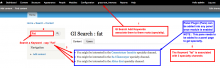
As the name suggests get you the common interest out of specific keyword.
The GI Search module adds the extra functionality to the search displaying the common term or URL you wish to focus when a certain "keyword" is searched. This module is not dependent on search but it takes the argument passed in URL to match with the manually entered keywords, bind them with title and URL of our choice, within the site or some external URL.
Thus purpose of this module is to enhance user search experience.
By providing binding of as many keywords as we want to a URL.
Features
* Enhances user experience in search without interfering the search.
* Works with default drupal search, Apache SOLr search ... etc.
* Only dependent on URL arguments.
* Manually added keywords to add more sense to search.
* Give clue to user about the trends followed throughout the website.
* Super light adds no extra load.
* Can also be used for featuring some specific URL where you want user
to have a look.
* Any number of keywords can be added using a user friendly interface.
* Using panels plugin can be placed anywhere we want to show suggestions.
* Developers can write there custom block using the functionality provided.