Still on Drupal 7? Security support for Drupal 7 ended on 5 January 2025. Please visit our Drupal 7 End of Life resources page to review all of your options.
This module delivers support for the Mapstraction javascript library, which provides an abstraction layer for the various map providers including Google, Yahoo!, and MapQuest. It allows you to quickly display maps on your site from multiple providers and switch between providers without worrying about differences in their APIs.
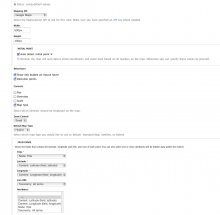
The module provides a Views style plugin and an API for developers to use maps elsewhere. When the Views style is used, it will display nodes as points on a map. The latitude/longitude points, info balloon contents, map icon, and one or more attributes can be provided by any view fields, including those from CCK. Other settings can be seen on the attached screen shot.
Note: As of 2021-06-16, this project appears to no longer be supported. If you are interested in taking this project over, or you as the project maintainer feel this message has been posted in error, please reply to #3214225: Subdomain appears to be unsupported.
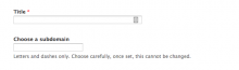
Easily create subdomains per user, taxonomy term, content type, or organic group. This module adds an easy text field to the entity where you can enter a subdomain for it.
User: e.g. "Mary" and all of her content at http://mary.example.com
Taxonomy: e.g. "Seattle" and all content tagged with it at http://seattle.example.com
Organic Group: e.g. "MyGroup" and all of its content at http://mygroup.example.com
Content type: e.g. "News" content type and all of its nodes at http://news.example.com
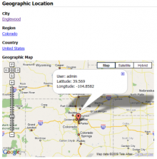
The geonames_cck module implements a CCK field type that uses geonames (http://www.geonames.org) to translate location names into their longitude and latitude coordinates.
This module was designed to work with the geomap (http://drupal.org/project/geomap) module. Locations are output using Geo microformats, and the geomap module will display any geo data on a google map.