Note: As of 2010/01/29, this module appears to no longer be supported. If you are interested in taking this module over, or you as the module maintainer feel this message has been posted in error, please reply to #360213: WeatherFacti seems abandoned.
If you are looking for a module with the same purpose, see Weather.
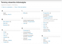
The Taxonomy VTN module provides an index for vocabularies, terms and nodes just like those you find at the end of reference or technical books. It supports synonyms, terms, related terms, and parent/child relations. The root Taxonomy VTN path is http://www.example.com/taxonomy_vtn
On June 15, 2009 I fixed a couple of problems: the master index would show the first description found for all the entries. The Node back link when coming from a parent/child page would send you back to the main vocabulary page with all the terms.
 Not attending DrupalCon Vienna 2025? We would love to hear why. Your feedback helps us understand the community better.