Enhance the editorial interface and improve the processes and workflows around creating, editing or removing content.

Leaflet GeoJSON

Leaflet GeoJSON powered map

Leaflet GeoJSON is a set of modules for creating Leaflet maps backed by GeoJSON data and leverage a bounding box strategy.

Why use Leaflet GeoJSON?

The Leaflet javascript library and its Drupal integration module are great tools for providing mobile-friendly, interactive maps based on your data. One benefit of combining Leaflet with Views GeoJSON is that you can leverage a bounding box strategy. Here's a definition from the OpenLayers site:

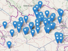
The BBOX strategy requests data within a bounding box. When the previously requested data bounds are invalidated (by browsing to some area not covered by those bounds), another request for data is issued

A standard use case goes like

  1. Create a GeoJSON feed using the Views GeoJSON module.
  2. Add the bounding box argument to the GeoJSON view.
  3. Use a leaflet map preset defined by the Leaflet module, in code or one of the integration modules.
  4. Put them all together using the Map pane CTools content type plug-in (7.x) or Page Manager (8.x)

Insert Video

Inserting a youtube video into WYSIWYG

This module adds an Insert button to video fields managed by the Media module.

SlideShare filter

This module creates a new filter so that users could embed slides from slideshare.net

Insert styles

Extends the Insert module with common image styles.

Currently the styles are:

Pages

Subscribe with RSS Subscribe to RSS - Content editing experience