The Mail Redirect module redirects ALL system generated email (see notes below that CC/BCC were not supported until the 3.x branches of D7/D8/D9) to a test mail domain or address. This is especially useful when doing site testing which uses a production database which is populated with real email addresses.
Works with any mail generated by drupal_mail().
General Usage:
redirect any system generated email to your configured email domain or address
usage (specific for 7.x-2.x and newer, see README for older releases):
- in your test site's settings.php set:
$conf = array('mail_redirect_opt' => "domain");
$conf = array('mail_redirect_domain' => "mydomain.com");
OR
$conf = array('mail_redirect_opt' => "address");
$conf = array('mail_redirect_address' => "myaddress@mydomain.com");
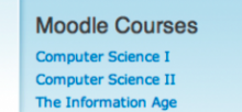
This is a module to display a block for the user with links to the Moodle courses they are members of. You have to provide it with the database login information that Moodle uses.
 Not attending DrupalCon Vienna 2025? We would love to hear why. Your feedback helps us understand the community better.