
The default formatter doesn't allow overwrite the default options and constants shared between vector overlays (Polygon, Polyline, Circle).
I attach a patch that extends the default formatter and allow to overwrite the leaflet's options.
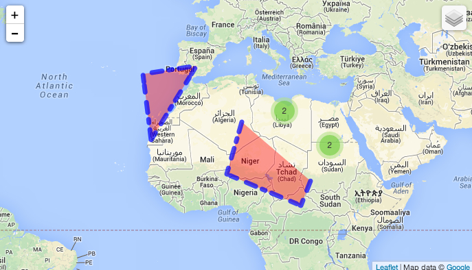
The first image show the formatter form and the second image a map with multi-value geofields.


Comments
Comment #1
mordonez CreditAttribution: mordonez commentedComment #2
mordonez CreditAttribution: mordonez commentedComment #3
mordonez CreditAttribution: mordonez commentedComment #4
mordonez CreditAttribution: mordonez commentedComment #5
mordonez CreditAttribution: mordonez commentedfixing whitespace errors.
Comment #6
c-c-m CreditAttribution: c-c-m commentedPatch applied successfully!
That's what I've done:
Thank you very much for your work mordonez, I really think this provides a necessary step forward in customizing maps that was leaflet module was lacking till now.
I have to admit, however, that the image you provided on this issue's description which displays several results and clusters I expected a different behaviour based on views instead of geofield formatter which only works per node basis. I really think this should also be implemented in leaflet_views submodule in order to extend this functionallity on a views-based map. I've never done such a thing, but I'll try to do it or help you if you need my help.
Comment #7
mordonez CreditAttribution: mordonez commentedthanks @c-c-m to review and test the patch
here the same patch with views support you mentioned in #6
Comment #8
mordonez CreditAttribution: mordonez commentedchange status to review the views integration
Comment #9
gcbThanks @mordonez: rolled into 1.0 with some tweaking.
Comment #10
c-c-m CreditAttribution: c-c-m commentedGlad to see this patch accepted. Good job.