
 Come together with the global Drupal community in Rotterdam, 28 Sept – 1 Oct 2026. Sessions, contribution, connection, and Early Bird savings until 8 June.
Would it be possible to add the ability of embedding a radar map into the page display? Would appear its flash content when looking at the providers website.
| Comment | File | Size | Author |
|---|---|---|---|
| #3 | yr-radar.png | 265.85 KB | tjodolv |
| #3 | yr-flash.png | 113.09 KB | tjodolv |

Comments
Comment #1
tjodolv commentedRadar maps are only available from yr.no as still gifs or a gif animation for use by modules like this. The flash animations on yr.no are not available for embedding. Also, only the gif radar maps over Norway are open for use outside the provider site. This is because of licensing issues.
The flash map with symbols used on most locations is not available for embedding either, unfortunately. I do think it would be possible to create one based on the info contained in the xml files this module gets from yr.no, but I don't know anything about flash.
I'll leave this open as a reminder in case anyone wants to have a go at it, or maybe I'll find the time to make an HTML/JS implementation of it.
Comment #2
polskikrol commentedThe licensing issue is only for hot linking to GIFs of radar maps outside of Norway?
With the addition of radar maps, it would really round out this module quite well. Not sure how one would generate a radar map image based on simply info contained in an xml file though. Would think there is much more data used to determine the information.
Comment #3
tjodolv commentedThe actual radar gifs are taken directly from weather-radars. Yr.no buys some from other nordic countries, but it is only allowed to use the images for Norway, as these are the ones that Yr's owners are in control of.
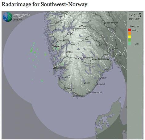
When I talk about "radar" images, I mean these:
http://drupal.org/files/issues/yr-radar.png
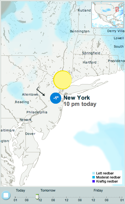
As for the maps with symbols, temperature and wind on them, as well as precipitation areas, they are flash animations, and Yr's licensing does not allow these to be embedded from outside their own site. These are the maps that look like this:
http://drupal.org/files/issues/yr-flash.png
While the precipitation shades require more information, a basic map with symbols, temperature and wind is quite possible, even without flash. One could also perhaps include surrounding locations and add to the map. I need some time to figure that out however, but I agree that it would be great, and whenever I have time, I'll work on it.
Comment #4
tjodolv commentedCreated a new issue where I gathered up all the feature requests.
#1178150: Feature suggestions and requests