Closed (won't fix)
Project:
GMap Module
Version:
6.x-1.x-dev
Component:
Miscellaneous
Priority:
Normal
Category:
Support request
Assigned:
Unassigned
Reporter:
Created:
22 Apr 2009 at 20:46 UTC
Updated:
14 Apr 2013 at 22:12 UTC

hi,
I have installed http://drupal.org/project/issues/geo and http://drupal.org/project/issues/geocode to get geocoding into CCK. Those two modules create a location CCK field and allow to automatically grab geo data from exif of uploaded images. Geo data is stored in a CCK field.
Now I try to get this shown on a gmap using the "GMap Style" View, provided by the GMap module.
I created a view with a "Page" to show the gmap. I added an "attachment" block to the base view to list the actual data that this view is based on.
gmapviewresult.png shows what I get with my current setup: You can see that there are indeed lat/lng data available for each node.
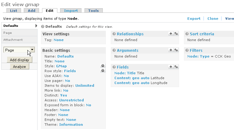
gmapview-definition.png shows the overal setup of my view: you can see the definition of the three fields that are listed in the table.
gmapview-gmapstyle.png shows the "style" options for the gmap: (the macro is ok as I confirmed by using the location module as geo data provider for a test) I choose to use Feilds as data source and then selected the two fields who are based on the cck geo field, one representing the lat, the other the lng value.
But apparently the map does not like this setup as there are no nodes shown on the map (notice the "no matchingnodes found" instead of the expected map.
Why does this not work? Any Idea what could be wrong with those geo data and how to fix it?
thank you
| Comment | File | Size | Author |
|---|---|---|---|
| gmapviewresult.png | 23.92 KB | ansorg | |
| gmapview-gmapstyle.png | 6.06 KB | ansorg | |
| gmapview-definition.png | 12.92 KB | ansorg |

Comments
Comment #1
johnvClosing this very old issue. Please reopen if it is still valid.