

Closed (fixed)
Project:
IP Geolocation Views & Maps
Version:
7.x-1.27
Component:
User interface
Priority:
Normal
Category:
Feature request
Assigned:
Reporter:
Created:
17 Apr 2013 at 10:26 UTC
Updated:
24 Sep 2015 at 11:34 UTC
Jump to comment: Most recent, Most recent file

Comments
Comment #1
rdeboerIs this using Google, Leaflet or Openlayers?
Comment #2
efruin commentedI'm experiencing the same thing using a Google map.
Comment #3
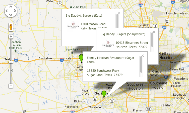
efruin commentedhere's a screenshot of what I'm seeing.
Comment #4
rdeboerI'll have a quick look to see if this is simply a parameter I need to pass to the Google Maps API. If it's not that simple, I welcome patches.
I suggest that you keep IP Geolocation Views and Maps but also install the "Leaflet" and "Leaflet More Maps" modules.
You can continue to use the View you have already created. All you have to do is flick the View style/format from "Map (Google, via IP Geolocaton)" to "Map (Leaflet, via IP Geolocation)".
Whit the Leaflet module, the marker balloons work as you describe.
With Leaflet by itself you only get one map (OSM Mapnik) to choose from, But after also installing "Leaflet More Maps" you'll see nearly 30 maps to choose from, including Google maps.
This (unrelated) issue has a screenshot showing Leaflet balloons with Google markers on a Bing map (just for something different again): http://drupal.org/node/1973064#comment-7314168
Comment #5
rdeboerGoogle seem to have had a change of hearts regarding the default behaviour of balloons. The behaviour you're requesting is default Google Maps API v2 behaviour. IP Geoloc Views and Maps uses Google Maps API v3.
On their InfoWindow documentation pages Google says:
If somebody wants this to be a configurable option, i.e. to allow selection of either Google Maps old-style vs Google Maps API V3 behaviour, then I welcome patches.
The files to modify are
js/ip_geoloc_gmap_multi_loc.jsandviews/ip_geoloc_plugin_style_map.incOther than that, as mentioned in #4, switch to the Leaflet plugin that comes with IP Geolocation Views and Maps and use Google Maps (or any other map) via Leaflet.
Comment #6
inky@inky3d.com commentedI was using the Google map. Switched to Leaflet and the markers work great. (I had also tested with OpenLayers - which was even worse)
Thanks for the advice
Comment #7
rdeboerAs mentioned above in #5 This is Google API v3 style. If you want Google API v2 style, switch to Leaflet or provide a patch to make this behaviour configurable.
Comment #8
anouHello,
here's a starter patch for this. My patch resolves 2 "problems":
Another step could be to close all balloons when you click on map...
Hope it'll helps.
Thank for your module and have a nice day.
Comment #9
PiroXXI commentedHi there,
Nice patch :) . It does the job pretty well.
One small feedback is that it doesn't yet work well with the "Marker balloons to open on initial display" option, as this balloon is not closed when an other one is opened.
Cheers,
Raphael
Comment #10
weri commentedThanks anou for the patch. I tested the patch and fixed also the problem described in comment #9 from PiroXXI.
I think the new patch is ready to commit.
Comment #12
weri commentedPatch format updated (was in phpstorm's format). Sorry!
Comment #13
weri commentedComment #15
weri commentedCreated patch now with git diff.....
Comment #17
weri commentedLast try :-/
Sorry about the many patches....
Comment #18
weri commentedComment #20
Alienpruts commentedHello weri,
how did you create the patch at comment 18? Certainly this is not by using git diff method? :)
I think your patches are failing because you should always create your patches onto the latest dev version of a module. Did you do that?
Comment #21
anouHere's the new patch with weri's changes. Thanks.
Comment #22
anouComment #23
anouSame patch, no
:-)
Comment #24
anouComment #25
weri commentedI tested the patch #23 from anou and it works as expected. Would be great to have this patch commited.
Comment #27
rdeboerCommitted. Thanks everyone!
Rik
PS: not tested -- no time, so please verify 7.x-1.x-dev if you can!
Comment #28
rdeboer