Support for Drupal 7 is ending on 5 January 2025—it’s time to migrate to Drupal 10! Learn about the many benefits of Drupal 10 and find migration tools in our resource center.
This module provides a field for geospatial data that can be added to entities. In other words end users can add points, lines or areas on a map as part of a content. This module is similar to the Geofield module, but spatial operations and data storage rely on PostGIS.
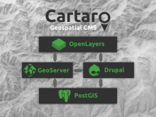 Cartaro is a Drupal distribution that provides support for spatial data. It seamlessly combines: